01
See the work before you contract
Send 25-50 representative frames. We label them at our cost, return the output and a per-class QA scorecard. You decide whether to scope a pilot after you have seen the labels, not before.
We transform satellite imagery, drone captures, LiDAR point clouds, GIS vectors, and change-detection scenes into clean labels, auditable QA, and export-ready datasets your model or GIS team can actually use.
Send 25-50 representative frames. We label them at our cost, return the output and a per-class QA scorecard. You decide whether to scope a pilot after you have seen the labels, not before.
Bill per labeled object when scope and volume are predictable. Bill per labeling hour when the workflow is exploratory or the schema is still firming up. Both models are on the table from the first scoping call.
We operate in CVAT, Labelbox, Roboflow, V7, Scale AI workflows, and most in-house labeling stacks. No platform migration on your end. If you have a custom tool, we learn it on the pilot.
On infrastructure asset classes, validated per delivery
Pavement, striping, lanes, boundaries, and surface condition labels — tied to real geography with QA trails.
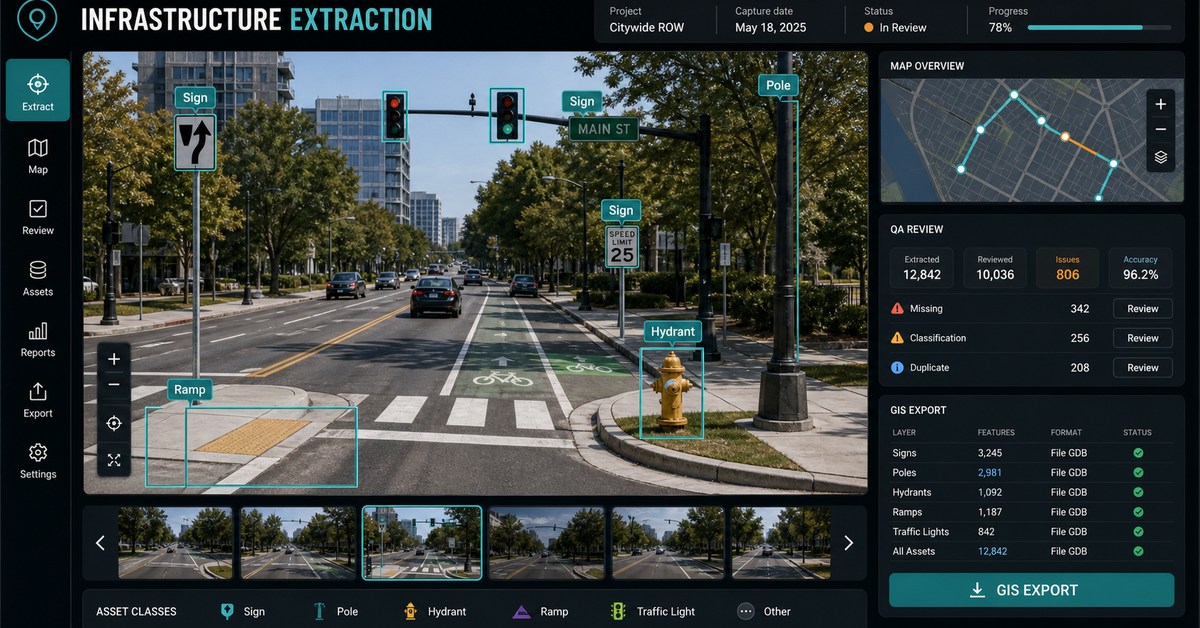
Signs, signals, poles, utilities, streetlights — bounding boxes, segmentation masks, and point labels with coordinate accuracy.
Roadway, street-level, and LiDAR imagery converted into QA-reviewed features your mapping/AI/asset teams can use immediately.
Spatial validation, coordinate-accuracy checks, and asset classification QA against authoritative GIS databases.
Deliveries in QGIS, ArcGIS, GeoJSON, COCO, KITTI, Mapillary — whatever your pipeline ingests.
Primary geospatial data annotation services authority for satellite, drone, LiDAR, GIS vector, change detection, QA, and file-format searches.
Buildings, roads, vegetation, water, land cover, infrastructure, point clouds, and GIS features labeled with spatial context.
GeoJSON, shapefiles, masks, point layers, classified point clouds, COCO, KITTI, Mapillary, and attribute tables.
Geometry checks, class consistency, topology review, duplicate detection, boundary validation, and export verification.
Modeled on the live Geospatial Solutions demos: the page should show what the buyer sends, what they review, what evidence stays visible, and what they receive.
Satellite scenes, drone captures, LiDAR point clouds, GIS vector layers, target classes, and output requirements.
Calibration labels, taxonomy rules, edge-case examples, and GIS-aware QA are reviewed before scaling.
Every batch keeps class definitions, source context, confidence, QA flags, and export checks visible.
Model-ready datasets in GeoJSON, shapefiles, segmentation masks, classified point clouds, or your pipeline format.
Pilot QA scorecard before production volume.
Final accuracy depends on imagery resolution, class ambiguity, and available ground truth.
Satellite, drone, aerial, LiDAR, GIS vectors, and customer-owned imagery.
GIS-aware review, geometry validation, source traceability, and export checks.
GeoJSON, shapefile, masks, point clouds, COCO, KITTI, Mapillary, CSV, or FileGDB handoff.
No vague discovery phase. You bring four or five things, we return a specific plan you can evaluate.
Every class has a labeled definition, edge-case examples, and QA rules calibrated against authoritative GIS databases. Add custom classes during pilot and we extend the taxonomy.
Every label is a complete GeoJSON feature with geometry, class, confidence, QA trail, and source provenance. Loads directly into your map, your trainer, or your validator — no conversion script.
{
  "type": "Feature",
  "geometry": {
    "type": "Polygon",
    "coordinates": [[[ -77.0364, 38.8951 ], ...]]
  },
  "properties": {
    "class": "crosswalk",
    "class_id": "CW_001",
    "mutcd_type": "continental",
    "confidence": 0.97,
    "qa_status": "approved",
    "qa_reviewer": "annotator_03",
    "qa_timestamp": "2024-08-15T14:23:17Z",
    "source_frame": "frame_847.jpg",
    "capture_timestamp": "2024-08-12T11:18:04-04:00",
    "schema_version": "gss-roads-v2.4"
  }
}No open-ended retainers. No "discovery phases" that bill for months without producing anything you can evaluate.
50-100 frames, your schema, your edge cases. We return a calibration set so you can see how we interpret your taxonomy before scale.
500 samples in 2-4 business days. Inter-annotator agreement scores, QA dashboard, format in your pipeline (GeoJSON, COCO, KITTI, Mapillary).
Production volume with SLA. 24/7 follow-the-sun capacity, 98%+ QA target, weekly delivery cadence.
Wire into your training pipeline, deploy custom validation rules, build out edge case mining. Optional embedded team.
These open the real, interactive demos on our main site — not screenshots, not videos. Click around before you decide to talk to us.
Three reasons: spatial expertise (we read coordinate systems natively, they don't), pilot speed (2-4 days vs 2-4 weeks), and pricing transparency (we publish per-frame rates, no enterprise sales gauntlet for a first project).
CVAT, Labelbox, Roboflow, V7, and Scale AI workflows. We can also build custom labeling tooling when off-the-shelf platforms can't enforce the spatial validation your project needs.
Yes. Multi-modal alignment is one of the things we're set up for — LiDAR point cloud annotation with cross-referenced camera imagery, geolocated metadata, and synchronized timestamps preserved through the pipeline.
Pilot can start within 48 hours of NDA execution. Send your data and target schema; we return labeled output by end of business day 3. No procurement cycle, no MSA required for the pilot.
Anchored in the NAIPAI pattern: ask aerial, drone, or satellite imagery useful questions, keep confidence and …
Send a representative sample, lock the taxonomy, review calibration labels, and get a small delivery package b…
Production annotation teams for infrastructure AI, remote sensing, mobile mapping, and GIS data programs, with…
Dispatch optimization, container tracking, and demand prediction built for roll-off dumpster companies — runni…
No purchase order, no master service agreement. Send a representative slice and a target schema; we return the labels in the format your pipeline already ingests.
Start a geospatial annotation pilot